")
Headlines:
- La Nina continues weak comeback in tropical rainfall pattern
- Western U.S. and eastern Europe get some rainfall relief from drought
- Atlantic hurricane season wakes up in second half of September, but storms stay over ocean
- Tropical cyclones contribute significantly to South Asian monsoon
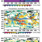
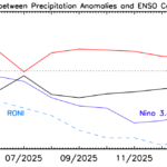
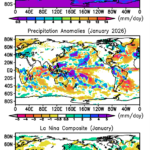
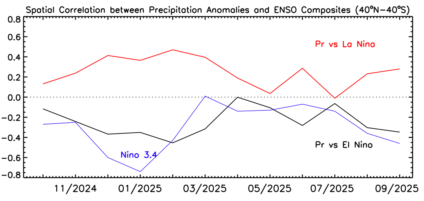
Tropical cyclone rainfall in the Atlantic is evident this month with the swath of maximum off the east coast of the U.S. (Fig.1 top and middle panels), where storms only started to occur in the second half of the month—a seasonal late start to activity. In South Asia tropical cyclones also contributed significantly to the positive anomaly across India, Indochina, China, and most of the Maritime Continent. The Nino 3.4 ENSO SST index in the central Pacific decreased a little this September to -0.4K (and -0.8K for the Relative 3.4 index), indicating a weak La Nina situation. And this surface forcing helped produce the tropical Asian anomalies—the positive rainfall anomalies over South Asia/Maritime Continent and the negative anomaly to the east stretching from New Guinea east-northeastward. Over the Indian Ocean the above normal rain over India gives way to dry conditions over the water centered at the Equator, with another narrow east-west strip of heavier rain in the anomaly figure over the tropical southern hemisphere. A similar rainfall anomaly pattern is evident over these areas in the La Nina composite (Fig. 1, bottom panel), indicating even the relatively weak La Nina ocean temperature index can be associated with at least a pattern of rainfall anomalies looking La Nina-like in the Indian Ocean to central Pacific region. The overall pattern correlation between this September’s rainfall anomaly pattern and the El Nino/La Nina composites (Fig. 1, bottom panel) shows a slightly higher positive correlation (~ +0.3) with the La Nina side of things (see Fig. 2),
Although northern California still had a wildfire early in the month, most of the western U.S. and Mexico achieved some drought relief with some rain and there was even a flash flood in Globe, AZ in which three people died. Parts of the southeast and northeast U.S. remained dry with a swath of about normal rain in between. Canada remained mainly dry. Some of South America was dry (e.g., southeast Brazil) and roughly fit the La Nina composite, but the rest of the continent did not. The Gulf of Mexico and Caribbean Sea were dry reflecting the lack of tropical cyclone activity there.

In the North Atlantic the swath of positive rain anomaly off the east coast of the U.S. and extending across to Europe denotes a sequence of tropical cyclones developing, intensifying, but remaining offshore. However, one of these storms, Hurricane Gabrielle, weakened on its trip across the Atlantic, but retained a remnant circulation that crossed over Portugal and Spain, perhaps picked up some added moisture from the Mediterranean, and produced major flooding in the eastern Spain region of Valencia (one report of 720 mm of rain), reminiscent of deadly flooding there a year ago.
The global totals (Table 1) reflect the La Nina effect with the land total being slightly above average and the ocean below average.
Table 1 Global precipitation and anomalies in September 2025.
| Mean Precipitation (September 1983-2024) | Precipitation (September 2025) | Precipitation anomaly (September 2025) |
Land+ocean | 2.83 | 2.77 | -0.05 |
Land | 2.27 | 2.34 | +0.07 |
Ocean | 3.07 | 2.96 | -0.11 |