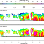
ESSIC senior faculty specialist Emily Smail created an informational video about the CoastWatch utilities tool. This tool helps with using satellite products to better understand and manage our oceans and coasts. The utilities are for viewing, analyzing and converting satellite image files, and the video will be on the CoastWatch website.
CoastWatch video will provide guidance for accessing satellite products
- Archive
Latest News

Christopher Smith Receives NOAA NWS Weather Prediction Center Peer Award
September 19, 2025
![Satellite seasonal temperature difference maps indicate how the Chesapeake Bay ecosystem and its organisms may respond to the temperature changes. Here, the maps show warmer than average water temperatures from January through March 2020, cooler than average from April through June, near average July through September, and slightly warmer than average October through December. The long-term baseline is from the years 2008-2019.]](https://essic.umd.edu/wp-content/uploads/2025/09/rv-chesapeake2-150x150.jpg)
Tracking Water Temperature with Satellites
September 18, 2025


Monitoring Ocean Climate Over 250 Years
September 12, 2025