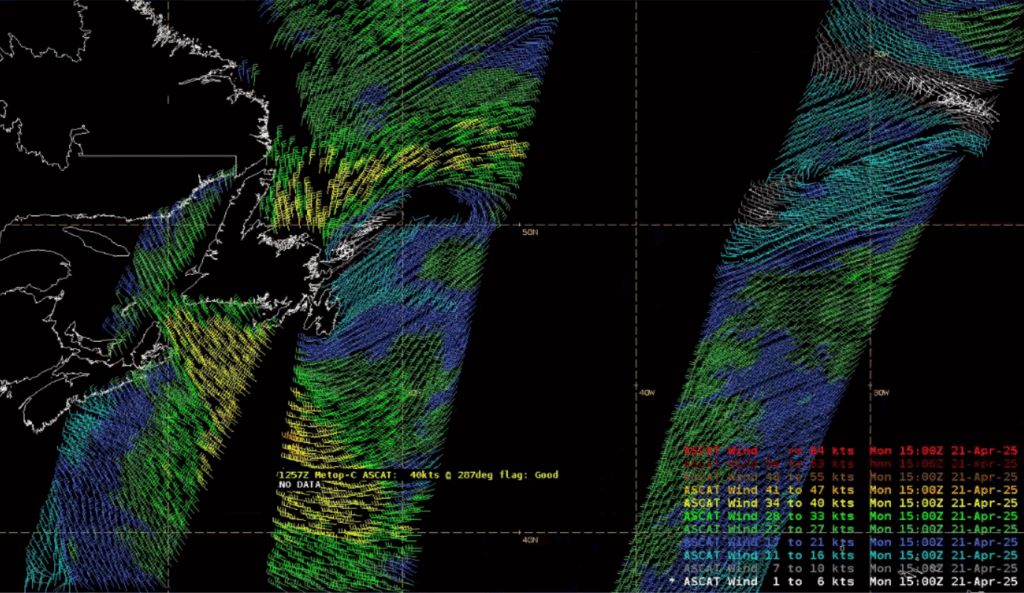
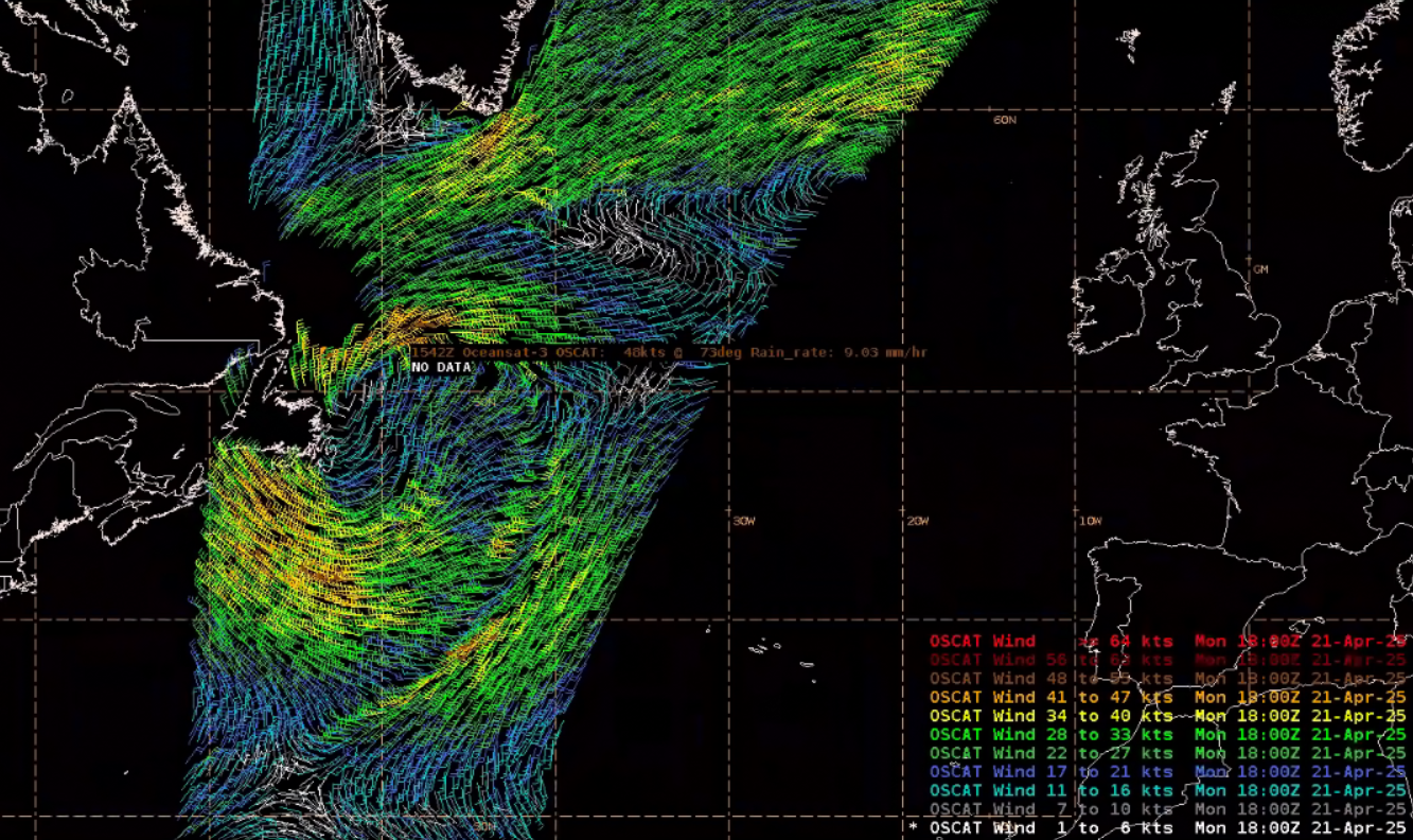
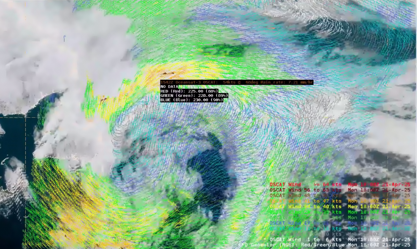
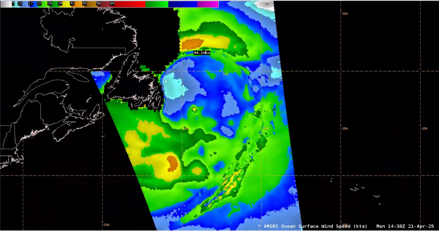
University of Maryland

Northwestern Atlantic April Extratropical Cyclone

UMD/ESSIC/CISESS GOES-R Satellite Liaison for NWS WPC

A late-season intense extratropical cyclone developed across the Northwest Atlantic after a frontal system pushed off the New England Coast over the weekend. The extratropical cyclone reached storm-force, meaning its sustained winds were between 48 and 63 kts (roughly 55 to 72 mph). GOES-East (GOES-19 replaced GOES-16 as the operational GOES-East satellite on April 4) Air Mass RGB imagery captured the intensification of the low pressure as it moved eastward and pushed off the coast of Newfoundland, from 0600 UTC 20 April to 0600 UTC 21 April 2025. Throughout the 24-hour time period, deeper oranges and reds can be seen enveloping the area of spin, suggesting an upstream troposphere fold helped provide high-levels of potential vorticity (PV) to fuel the intensification. From 0600 UTC 20 April to 0600 UTC 21 April 2025, the minimum central pressure of the system dropped from 998 to 982 mb, as winds ramped up from sub-gale to storm-force.

Figure 1: GOES-East Air Mass RGB imagery from 0600 UTC 20 April to 0600 UTC 21 April 2025. From CIRA Slider

Figure 2: The National Weather Service (NWS) Ocean Prediction Center (OPC) Atlantic Surface Analysis valid at 0600 UTC 20 April (left) and 0600 UTC 21 April 2025 (right).

Well to the south of Newfoundland, a RadarSat Constellation Mission -1 (RCM-1) Synthetic Aperture Radar (SAR RCM) pass at ~1000 UTC 21 April 2025 observed strong northwest winds behind the cold front, with sustained winds around 40 kts. SAR winds provide a much higher spatial resolution of 500-m in comparison to scatterometers (12.5 km).

Figure 3: RCM-1 SAR Imagery valid ~1000 UTC 21 April 2025. RADARSAT Constellation Mission Imagery Copyright Government of Canada 2024. RADARSAT is an official mark of the Canadian Space Agency. Credit: NESDIS/STAR

After 1200 UTC 21 April 2025, the low pressure had slightly weakened back down to gale-force. Metop-C ASCAT scatterometer passes at ~1257 and ~1435 UTC observed ocean surface winds around 40 kts on the system’s southern flank, with a small area of gales also developing along the occluded front north of the circulation.

Figure 4: Metop-C ASCAT passes valid at ~1257 and ~1435 UTC 21 April 2025. This image was exported from AWIPS.

The OceanSat-3 Scatterometer (OSCAT-3) was recently made available in AWIPS workstations for OPC forecasters. Following a couple of hours behind ASCAT, the wide swath provided an additional look at the wind field’s evolution. The OSCAT-3 pass at ~1542 UTC 21 April 2025 picked up on an expansion and strengthening of gale-force winds along the occluded front. A few wind observations even reached storm-force, but the observations were isolated and in areas of convection. OSCAT-3 wind retrievals can be overestimated and compromised by rain contamination as the Ku-band scatterometer has a shorter wavelength compared to ASCAT and can result in increased backscatter. Overlaying the OSCAT-3 pass on GOES-E GeoColor imagery confirmed the erroneous wind values located in area of thick cloud cover.

Figure 5: OSCAT-3 pass valid at ~1542 UTC 21 April 2024 (left), and the pass overlaid with GOES-East Geocolor imagery (right). Note the 54 kt wind value is found in a location of thick cloud cover, and an observed Rain Rate of 7.21 mm/hr when sampling in AWIPS. This image was exported from AWIPS.

GCOM-W/AMSR2 microwave emission-derived ocean surface winds were also available from an hour prior to confirm the expansion of the gale-force winds on the northern side of the extratropical cyclone. Estimated wind speeds also reached 44 kts, supporting the strengthening seen in OSCAT-3, but not yet at storm-force.

Figure 6: GCOM-W AMSR2 Ocean Surface Wind Speeds at ~1438 UTC 21 April 2025. This image was exported from AWIPS.

The strong winds across the Northwest Atlantic drove large wave heights to develop. Significant Wave Heights observed by the Sentinel-3b/SRAL altimeter around ~1400 UTC 21 April 2025 reached 6.5 meters, or in excess of 21 feet. The NWS OPC North Atlantic 72 Hour Wind & Wave Forecast provided ample lead time of the Significant Wave Heights (average height of the highest one-third of the waves) in excess of 6 meters south of Newfoundland.

Figure 7: Sentinel-3b/SRAL altimeter wave observations at ~1400 UTC 21 April 2025. This image was exported from AWIPS.
Figure 8: NWS OPC North Atlantic 72 Hour Wind & Wave Forecast issued at 1953 UTC 18 April, valid for 1200 UTC 21 April 2025.

Sea Spray was an additional hazard observed off the coast of Newfoundland on 21 April 2025. GOES-East Sea Spray RGB imagery from 1600 to 1800 UTC 21 April 2025 showed the sea spray (medium cyan to gray) developing into cloud streets downstream northeast of Newfoundland. JPSS/VIIRS provided a higher resolution view of the sea spray at ~1755 UTC 21 April 2025. Note that the Shortwave Infrared Band saturated the ‘Red’ part of the RGB composite due to sun glint, causing the scene to appear quite red overall.

Figure 9: GOES-East Sea Spray RGB valid from 1600 to 1800 UTC 21 April 2025. From CIRA Slider
Figure 10: JPSS/VIIRS Sea Spray RGB valid at ~1755 UTC 21 April 2025. From CIRA Slider

The system regained storm-force strength as it pushed northeastward on Tuesday. OSCAT-3 showed the enhancement of the Greenland tip jet, with a narrow strip of winds near 50 kts.

Figure 11: OSCAT-3 scatterometer observations at ~1455 UTC 22 April 2025. This image was exported from AWIPS.
Figure 12: NWS OPC Atlantic Surface Analysis valid at 1200 UTC 22 April 2025, with the low pressure over the northern Atlantic enhanced with a trough on the system’s northwest side to produce storm-force winds.

The system caused many vessels to avoid the far northern Atlantic on the morning of 23 April 2025, with the latest NWS OPC Atlantic Surface Analysis still showing storm-force winds south of Greenland.

Figure 13: Vessel locations at ~1320 UTC 23 April 2025 from marinetraffic.com
Figure 14: NWS OPC Atlantic Surface Analysis valid 0600 UTC 23 April 2025.
Picture of Christopher Smith

Christopher Smith

Christopher Smith joined ESSIC/CISESS, University of Maryland in 2023 and is the GOES-R Satellite Liaison for the NWS Weather and Ocean Prediction Centers. Smith works to interpret experimental satellite imagery and products, and make such products available to forecasters and the NWS for a route to operations. He trains forecasters how to use satellite imagery in weather forecasting, while also delivering forecaster feedback to satellite developers to maximize meteorological satellite capabilities. Smith is an alumni of the UMD Atmospheric & Oceanic Science (AOSC) Department, and his long-term interests include infusing AI-Satellite Products to increase lead time in decision making for forecasters.
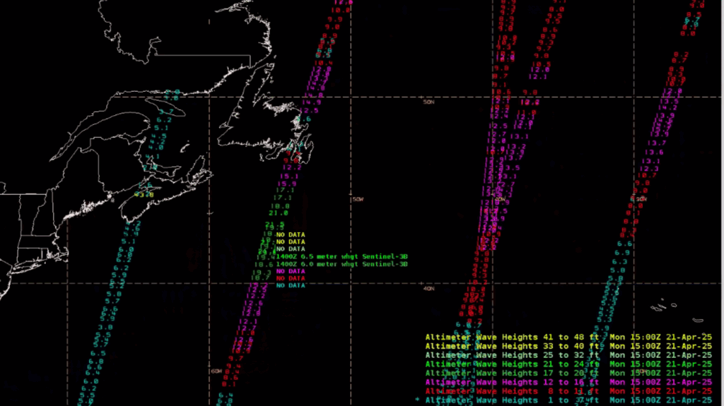
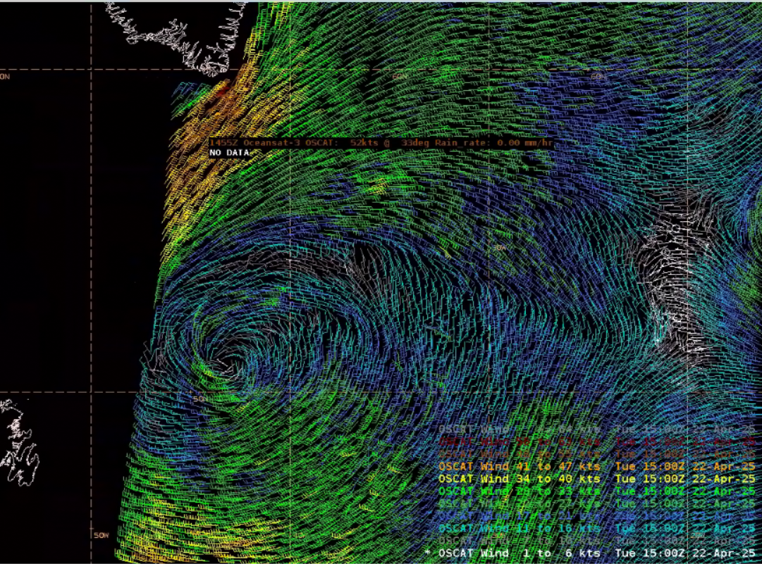
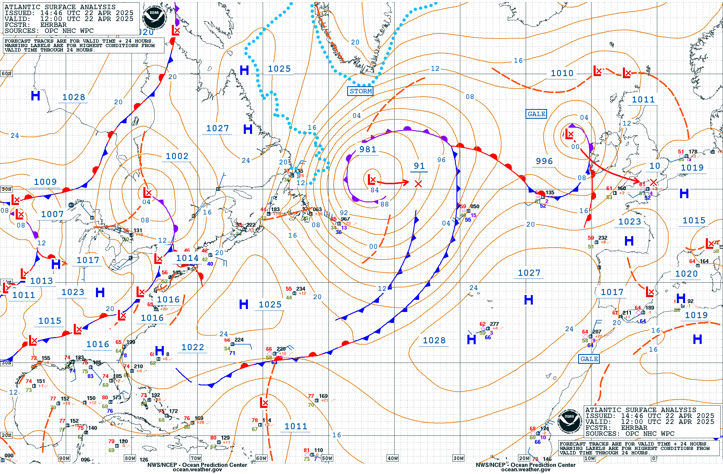
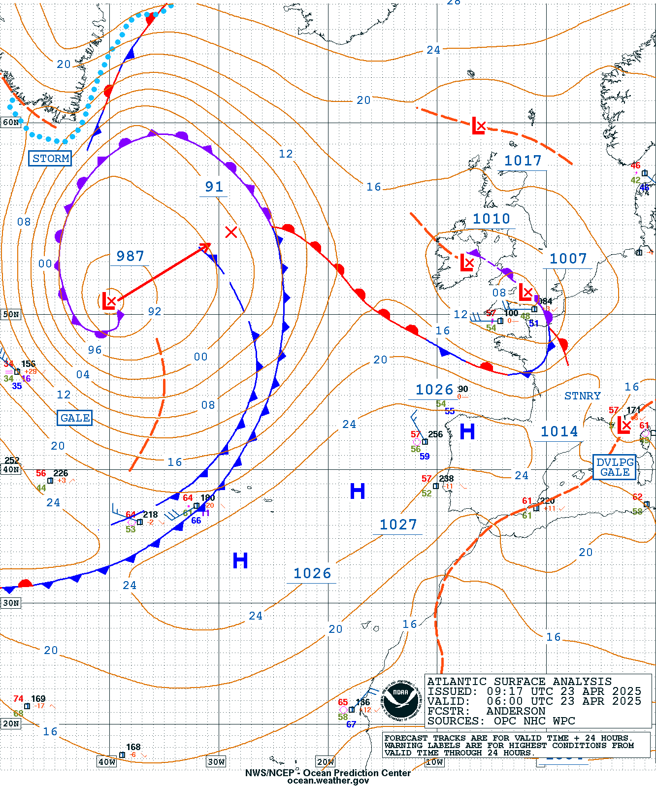