Home » Cazzy Medley » Page 23

Author: Cazzy Medley

Caption: The Water Point Viewer’s current water points stretch from Mali to Somalia.

ESSIC Scientist Expands Water Availability Prediction in East and West Africa

ESSIC Researcher Kimberly Slinski is the Principal Investigator on “Earth Observation-Based Monitoring and Forecasting of Rangeland Water Resources”, a newly funded project that aims to develop new capabilities for monitoring and forecasting water availability in African rangeland ponds. The project team includes Shrad Shukla and Chris Funk of the University of California Santa Barbara, Mike Jasinski of NASA GSFC, and Gabriel Senay of USGS.

Read More »
Tractor on a paddy field in Mekong Delta, Vietnam

Can the Mekong Delta be saved from drowning?

May 6, 2022 – The Mekong Delta in Viet Nam could be nearly fully submerged by the end of the century if urgent actions are not taken across the river basin. Continuing with business as usual could drown 90% of this agro-economic powerhouse that’s home to nearly 20 million people – with immense local and global impacts.

Read More »
Striping of MetOp-A MHS on July 1, 2019

Quantifying and Characterizing Striping of Microwave Humidity Sounder With Observation and Simulation

ESSIC/CISESS scientists John Xun Yang, Yalei You, and Rachael Kroodsma are co-authors on a new paper in IEEE Transactions on Geoscience and Remote Sensing alongside Sidharth Misra from NASA Jet Propulsion Laboratory and William Blackwell from MIT Lincoln Laboratory. Blackwell is also a two-time speaker for the ESSIC Seminar Series, the most recent of which can be viewed here.

Read More »
Suspended matter concentration and light attenuation are two satellite water quality products that could be used in combination with other types of data for monitoring water quality improvements and in assessments to determine attainment of water quality standards in Chesapeake Bay. EPA is leading the Chesapeake Bay Program partnership to restore the health of Chesapeake Bay.

Ron Vogel Advises Chesapeake Bay Program

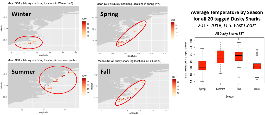
Ron Vogel, ESSIC/CISESS Senior Faculty Specialist, served as a subject matter expert at a scientific advisory panel of the Chesapeake Bay Program (CBP), the EPA-led partnership to restore a healthy Chesapeake Bay. The panel sought to advance the CBP’s current water quality data monitoring program to include new technologies such as satellites to improve its water quality assessments. Vogel outlined the current state of the science of satellite data products available for water quality analysis, including surface water light attenuation and suspended matter concentration.

Read More »
A visualization of Living Breakwaters in New York Harbor, one of the case studies in this paper.

Refining Coastline Management with Three Case Studies

ESSIC Visiting Associate Research Professor Ariana Sutton-Grier has a new paper out alongside co-authors from UMD and other international organizations. In the study, titled “Innovations in Coastline Management With Natural and Nature-Based Features (NNBF): Lessons Learned From Three Case Studies”, researchers discuss three case studies on innovative coastal resilience projects in the US that use natural and nature-based features: 1) Living Breakwaters in New York Harbor; 2) the Coastal Texas Protection and Restoration Study; and 3) the South Bay Salt Pond Restoration Project in San Francisco Bay.

Read More »
Santiago Gasso poses in front of a blurred landscape

Gassó Talks Earth Science In Spanish Interviews

On the occasion of Earth Day, ESSIC Scientist Santiago Gassó was interviewed by several international and domestic media outlets for Spanish audiences. The interviews consisted of brief live and recorded video segments meant to highlight NASA’s commitment to Earth science observations since its inception.

Read More »

A New NOAA Blended Soil Moisture Product that Does Not Rely on Model Climatology

ESSIC/CISESS Scientists Jifu Yin, Jicheng Liu and Ralph Ferraro published a new article last month that discussed their work with NOAA’s Soil Moisture Operational Product System (SMOPS). SMOPS is developed by National Oceanic and Atmospheric Administration (NOAA) to provide the real time blended soil moisture (SM) for Numeric Weather Prediction and National Water Model applications.

Read More »