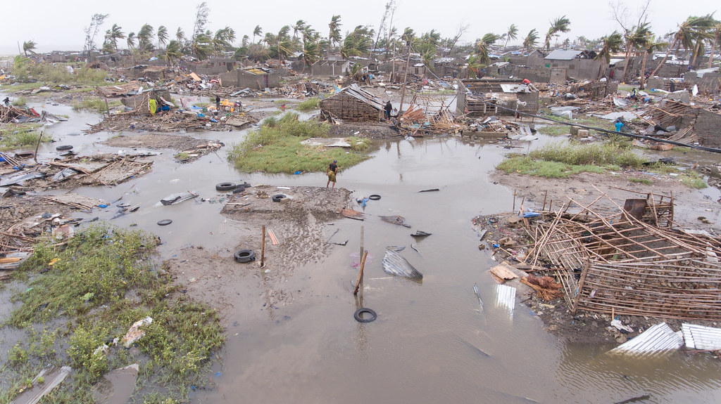
Home » Highlights » Page 19

Category: Highlights

Page 1 of the SOLAS report; an image of a porthole looking towards an ocean is the background, with "US SOLAS Science Plan" appearing in front of it.

Gassó and Zamora Co-Author SOLAS Science Plan

Santiago Gassó is one of the co-authors in the recently released science plan by the US Surface Ocean – Lower Atmosphere Study (SOLAS), a global and multidisciplinary research project established to provide international science coordination and capacity building. SOLAS is focused on understanding the key biogeochemical-physical interactions and feedbacks between the ocean and atmosphere that are critical elements of climate and global biogeochemical cycles.

Read More »
Isaac Moradi smiles for the camera, wearing a red gridded button-up and a red tie

Congratulations to Isaac Moradi, Newly Elected Member of the University State Senate

ESSIC/CISESS Research Scientist Isaac Moradi has been elected to the University State Senate as one of the Professional-Track Faculty members. The University Senate, composed of faculty, staff, students, and administrators, is one of the largest and most influential governing bodies at the University of Maryland. As a member of the senate, Moradi will help advise the University President on campus policy matters and concerns, including education, budget, personnel, campus-community, long range plans, facilities, and faculty, staff and student affairs.

Read More »
Artificial oyster reefs parallel to the shoreline is a natural way to slow the rate of erosion by catching the wave energy. Credit: USFWS

Innovative Use of Satellite Data Establishes Water Clarity Improvement at Restored Oyster Reefs

Ron Vogel, ESSIC senior faculty specialist, recently co-authored a NOAA Technical Memorandum with colleagues from NOAA’s National Marine Fisheries Service, titled “Using Satellite-Derived Total Suspended Matter Data to Evaluate the Impacts of Tributary-Scale Oyster Restoration on Water Clarity.” In the study, the team sought to explore whether large-scale oyster restoration in the Chesapeake Bay, on the order of 100s of acres, can produce improvements in water clarity that are measurable, and whether satellites can be a tool to help measure that change.

Read More »
Figure: Case study of August 11, 2018. Convective/stratiform split of the raining system observed by GPM-core satellite (orbit: 025293). From left to right: (a) PMW-retrieved (GPROF) – a current operational benchmark; (b) Dual-frequency Precipitation Radar-derived product – the truth; (c) Bayesian model prediction ResNetV2; (d) Entropy for the Bayesian model prediction – uncertainty map.

Using Bayesian Deep Learning to Improve Precipitation Retrievals

ESSIC/CISESS Scientist Veljko Petković co-authored a study on the application of new and emerging field of BDL concepts to mitigate problems associated with the accuracy of precipitation retrievals from satellite-borne passive microwave (PMW) radiometers, which was published in IEEE Geoscience and Remote Sensing Letters.

Read More »
Figure: A rosette of Niskin (seawater sampling) bottles used to collect discrete water samples at specific, predetermined depths. Instruments for measuring depth, temperature, and conductivity (which helps determine salinity) are inside of the ring near the bottom (not visible). (Photo provided to Jiang et al. by Sabine Mecking of the University of Washington for the publication).

Jiang Leads International Effort to Create New Data Standard for Oceanographic Research

ESSIC/CISESS Scientist Li-Qing Jiang, who works on the Ocean Carbon Acidification Data System (OCADS) project at the National Center for Environmental Information (NCEI), coordinated a massive effort by the international community to develop a best practice data standard for discrete bottle-based chemical oceanographic data. The study, co-authored by ESSIC/CISESS Scientist Alex Kozyr and esteemed scientists at over 30 institutions in 10 countries, was published on January 21st in Frontiers in Marine Science.

Read More »
The title slide of the AMS short course

CISESS Presents Two AMS Short Courses

Scott Rudlosky and Joseph Patton led an AMS short course titled “Accessing and Applying Geostationary Lightning Mapper Observations” on January 5 and 6. This two-part course introduced the GLM observations and imagery using GLM flash skeletons and gridded products used by the National Weather Service. Participants were shown how to access archived and real-time imagery before conducting a hands-on exercise illustrating their new-found skills. Additional information can be found at this link: Accessing and Applying Geostationary Lightning Mapper Observations.

Read More »
Snow falling around some pine trees

Snowfall Rate Product Captures First Nor’easter in 2022

The first nor’easter of 2022 swept through the Mid-Atlantic and the Northeast on January 2-4, 2022, resulting in a heavy snow accumulation of up to 14 inches in Virginia and southern Maryland and stranding hundreds of drivers on Interstate 95 in Virginia. The NOAA NESDIS Snowfall Rate (SFR) product captured the evolution of the snowstorm with retrievals from the Advanced Technology Microwave Sounder (ATMS) sensor aboard the S-NPP and NOAA-20 satellite missions, and the AMSU-A/MHS sensors aboard NOAA-19, Metop-B, and Metop-C.

Read More »
Frank Monaldo in the video

NASA/NOAA Tech Will Aid Marine Oil Spill Response

As part of the NASA grant, UMD, NASA Jet Propulsion Laboratory, NOAA, United States Coast Guard, Watermapping Ltd., Maryland Department of Agriculture, Environment Canada, and Marine Spill Response Corporation participated in an experiment to compare oil thickness measurements (both in situ and remotely) in the hopes of validating an oil thickness product. By finding the thickest oil layers, researchers can identify key zones to bring in remediation equipment and clean up the most harmful oil in the environment. ESSIC Senior Faculty Specialist Frank Monaldo is involved in this field work and is featured in a video that highlights this work.

Read More »