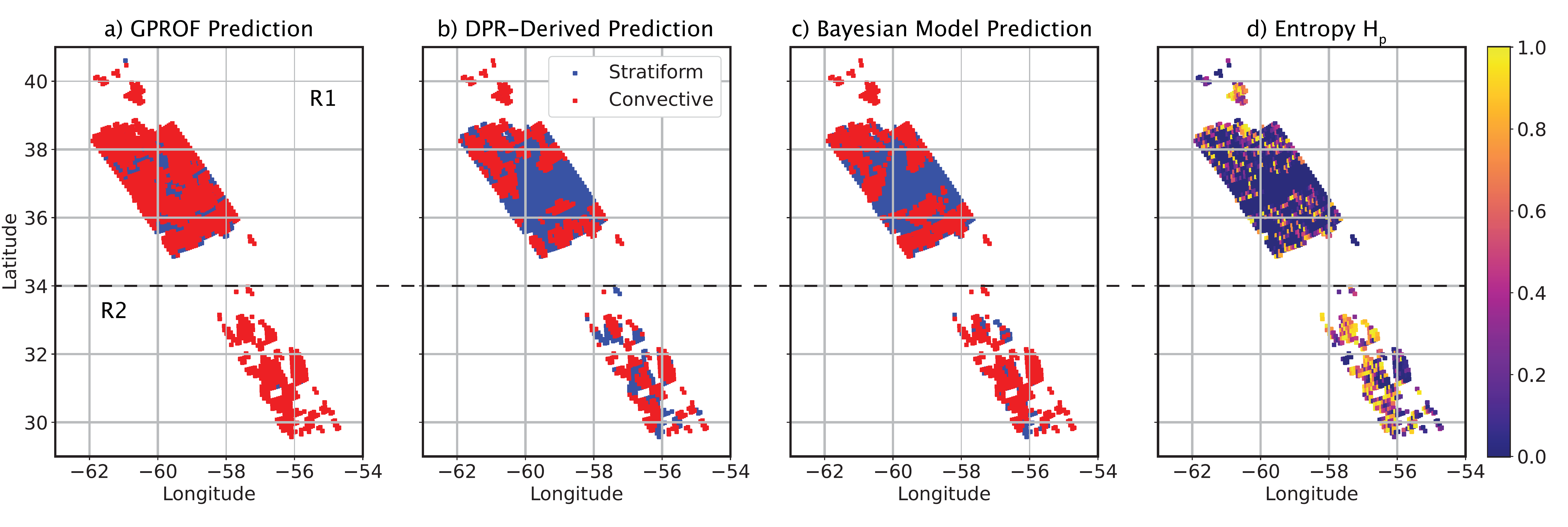
Home » Highlights » Page 23

Category: Highlights

Figure: Case study of August 11, 2018. Convective/stratiform split of the raining system observed by GPM-core satellite (orbit: 025293). From left to right: (a) PMW-retrieved (GPROF) – a current operational benchmark; (b) Dual-frequency Precipitation Radar-derived product – the truth; (c) Bayesian model prediction ResNetV2; (d) Entropy for the Bayesian model prediction – uncertainty map.

Using Bayesian Deep Learning to Improve Precipitation Retrievals

ESSIC/CISESS Scientist Veljko Petković co-authored a study on the application of new and emerging field of BDL concepts to mitigate problems associated with the accuracy of precipitation retrievals from satellite-borne passive microwave (PMW) radiometers, which was published in IEEE Geoscience and Remote Sensing Letters.

Read More »
Figure: A rosette of Niskin (seawater sampling) bottles used to collect discrete water samples at specific, predetermined depths. Instruments for measuring depth, temperature, and conductivity (which helps determine salinity) are inside of the ring near the bottom (not visible). (Photo provided to Jiang et al. by Sabine Mecking of the University of Washington for the publication).

Jiang Leads International Effort to Create New Data Standard for Oceanographic Research

ESSIC/CISESS Scientist Li-Qing Jiang, who works on the Ocean Carbon Acidification Data System (OCADS) project at the National Center for Environmental Information (NCEI), coordinated a massive effort by the international community to develop a best practice data standard for discrete bottle-based chemical oceanographic data. The study, co-authored by ESSIC/CISESS Scientist Alex Kozyr and esteemed scientists at over 30 institutions in 10 countries, was published on January 21st in Frontiers in Marine Science.

Read More »
The title slide of the AMS short course.

CISESS Presents Two AMS Short Courses

Scott Rudlosky and Joseph Patton led an AMS short course titled “Accessing and Applying Geostationary Lightning Mapper Observations” on January 5 and 6. This two-part course introduced the GLM observations and imagery using GLM flash skeletons and gridded products used by the National Weather Service. Participants were shown how to access archived and real-time imagery before conducting a hands-on exercise illustrating their new-found skills. Additional information can be found at this link: Accessing and Applying Geostationary Lightning Mapper Observations.

Read More »
Snow falling around some pine trees.

Snowfall Rate Product Captures First Nor’easter in 2022

The first nor’easter of 2022 swept through the Mid-Atlantic and the Northeast on January 2-4, 2022, resulting in a heavy snow accumulation of up to 14 inches in Virginia and southern Maryland and stranding hundreds of drivers on Interstate 95 in Virginia. The NOAA NESDIS Snowfall Rate (SFR) product captured the evolution of the snowstorm with retrievals from the Advanced Technology Microwave Sounder (ATMS) sensor aboard the S-NPP and NOAA-20 satellite missions, and the AMSU-A/MHS sensors aboard NOAA-19, Metop-B, and Metop-C.

Read More »
Frank Monaldo in the video.

NASA/NOAA Tech Will Aid Marine Oil Spill Response

As part of the NASA grant, UMD, NASA Jet Propulsion Laboratory, NOAA, United States Coast Guard, Watermapping Ltd., Maryland Department of Agriculture, Environment Canada, and Marine Spill Response Corporation participated in an experiment to compare oil thickness measurements (both in situ and remotely) in the hopes of validating an oil thickness product. By finding the thickest oil layers, researchers can identify key zones to bring in remediation equipment and clean up the most harmful oil in the environment. ESSIC Senior Faculty Specialist Frank Monaldo is involved in this field work and is featured in a video that highlights this work.

Read More »
Figure: An MHW in Barrow AP in 2007, indicated by sea surface temperature (SST, solid black), climatological SST (SSTc, dotted green), MHW SST criterion (95th percentile SST, solid green), long-term mean summer temperature (LMST, solid blue), and surface air temperature (SAT, dotted black).

Marine Heat Waves in the Arctic Ocean

ESSIC/CISESS/SCSB visiting research scientist Tom Smith has a new article in press at Geophysical Research Letters that analyzes events of extremely warm waters in the oceans known as marine heatwaves (MHWs).

Read More »

VIIRS Capable of Detecting Shipping Container Backlog in Light of Supply-Chain Challenges

ESSIC/CISESS Senior Faculty Specialist Yan Bai is a part of a NOAA Center for Satellite Applications and Research (STAR) project alongside Changyong Cao, STAR/SMCD/SCDA. The scientists found that VIIRS imaging bands can detect shipping containers at ports under clear sky conditions, despite its moderate resolution and the weak signal. This may enable them to monitor the port activities such as shipping container backlog in light of supply-chain challenges as widely discussed in the media. Figure 1 shows that more than 50 ships were found in the port of Los Angeles on October 1, 2021, compared to about a dozen two years ago, which indicates a potential backlog on that day.

Read More »