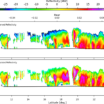
ESSIC visiting research scientists Ralph Ferraro and Huan Meng, post-doctoral associate Jun Dong, faculty specialist Michael Folmer, associate research scientist Cezar Kongoli, and assistant research scientist Nai-Yu Wang have an article in Eos, which is published by the American Geophysical Union. The article, “Snowfall Rates from Satellite Data Help Weather Forecasters,” describes how NOAA satellite data is used to generate maps that provide information on snowfall rates during snowstorms. Snowfall rates are based on satellite observations of microwave radiation from cloud ice content and land and ocean surfaces. The maps display the relevant data for weather forecasters.
ESSIC scientists publish article on snowfall rates
- Archive
Latest News

Christopher Smith Receives NOAA NWS Weather Prediction Center Peer Award
September 19, 2025
![Satellite seasonal temperature difference maps indicate how the Chesapeake Bay ecosystem and its organisms may respond to the temperature changes. Here, the maps show warmer than average water temperatures from January through March 2020, cooler than average from April through June, near average July through September, and slightly warmer than average October through December. The long-term baseline is from the years 2008-2019.]](https://essic.umd.edu/wp-content/uploads/2025/09/rv-chesapeake2-150x150.jpg)
Tracking Water Temperature with Satellites
September 18, 2025


Monitoring Ocean Climate Over 250 Years
September 12, 2025