The MiRS Science Team, composed of ESSIC/CISESS scientists Yong-Keun Lee, Yan Zhou, and Christopher Grassotti, as well as NOAA STAR scientist Mark Liu and Shuyan Liu of CIRA, published a paper this week titled “In‐Depth Evaluation of MiRS Total Precipitable Water From NOAA‐20 ATMS Using Multiple Reference Data Sets” in Earth and Space Science. Lee was the first author of the study.
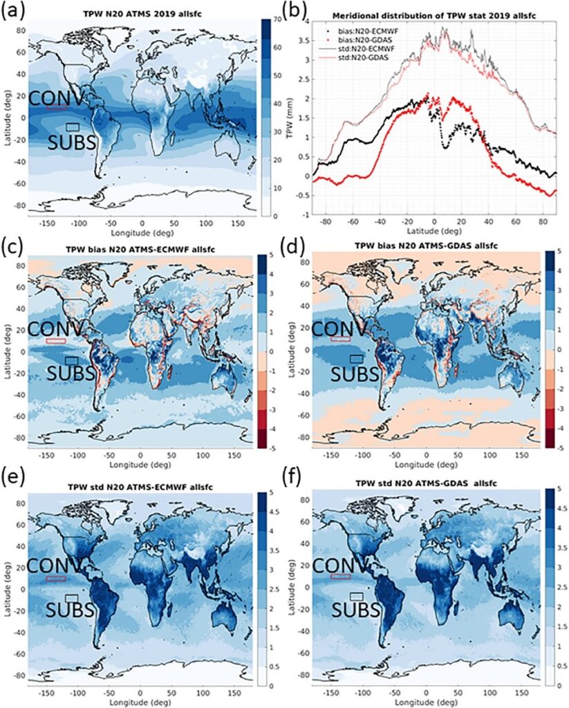
In the study, one full year (2019) of MiRS total precipitable water (TPW) retrievals from NOAA-20/ATMS measurements were subjected to a detailed validation effort, including comparisons to analyses from European Centre for Medium-Range Weather Forecasts/Global Data Assimilation System (ECMWF/GDAS), radiosonde measurements, and ground based GPS estimates. Both spatial and temporal patterns of retrieval performance were analyzed. Since the MiRS TPW estimates from multiple satellite measurements are a major component of the operational blended (and advected) TPW products, the study can serve as a benchmark for both developers and users of the product in their own applications. Figure 1 below shows an analysis of the annual average spatial distribution of retrieved TPW, along with corresponding differences with ECMWF and GDAS analyses.

Yong-Keun Lee is an Associate Research Scientist in the Earth System Science Interdisciplinary Center of the University of Maryland, College Park. He received a B.S. and a M.S. in Atmospheric Science from Seoul National University, and received a Ph.D. in Atmospheric Science from Texas A&M University. He is working on the NOAA Microwave Integrated Retrieval System (MiRS) which is the official operational satellite microwave retrieval algorithm currently being run on data from more than 7 different polar and non-polar orbiting satellites. His interests include remote sensing and data assimilation.
Christopher Grassotti received a B.S. degree in earth and space science from the State University of New York at Stony Brook, Stony Brook, NY, USA, in 1982, tan M.S. degree in meteorology from the University of Wisconsin-Madison, Madison, WI, USA, in 1986, and an M.S. degree in viticulture and enology from AgroMontpellier, Montpellier, France, in 2007. From 1986 to 1991 and again from 1993 to 2005, he was a Research Associate, Senior Research Associate and Staff Scientist with Atmospheric and Environmental Research, Inc., Lexington, MA, USA. From 1991 to 1993, he was with the Atmospheric Environmental Service, Environment Canada, Dorval, QC, Canada. Since 2008, he has been with the National Oceanic and Atmospheric Administration, NOAA Center for Satellite Applications and Research, National Environmental Satellite, Data, and Information Service, College Park, MD, USA. He has been a Senior Faculty Specialist with ESSIC/CISESS since 2015.
Yan Zhou received the B.S, from Zhejiang University, China; the M.S. from the University of Georgia, U.S.; and the Ph.D. from the University of Maryland, U.S.; all in the major of Atmospheric Science. From 2015 to 2018, she worked for the CICS-MD Observing System Simulation Experiment (OSSE) Project at the Earth System Science Interdisciplinary Center (ESSIC), University of Maryland. Since 2019, she has worked at the ESSIC, in cooperation with NOAA/STAR for the Microwave Integrated Retrieval System (MiRS) project


