Tag: Satellite Calibration and Validation

VIIRS Capable of Detecting Shipping Container Backlog in Light of Supply-Chain Challenges

ESSIC/CISESS Senior Faculty Specialist Yan Bai is a part of a NOAA Center for Satellite Applications and Research (STAR) project alongside Changyong Cao, STAR/SMCD/SCDA. The scientists found that VIIRS imaging bands can detect shipping containers at ports under clear sky conditions, despite its moderate resolution and the weak signal. This may enable them to monitor the port activities such as shipping container backlog in light of supply-chain challenges as widely discussed in the media. Figure 1 shows that more than 50 ships were found in the port of Los Angeles on October 1, 2021, compared to about a dozen two years ago, which indicates a potential backlog on that day.

Read More »
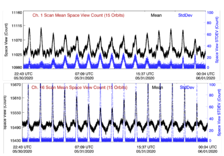
Figure: A lunar intrusion (LI) case occurring on May 31, 2020. Plotted are the original space view counts (black dots) and their standard deviation (blue dots) for NOAA-20 ATMS Channel 1 and 16 during the LI event.

Advanced Technology Microwave Sounder Radiance Data Products Calibration and Evaluation

ESSIC/CISESS Scientist Hu “Tiger” Yang has a new article on the Advanced Technology Microwave Sounder (ATMS) in press at IEEE Transactions on Geoscience and Remote Sensing. The Advanced Technology Microwave Sounder (ATMS) is a passive microwave radiometer for the current generation of polar-orbiting meteorological satellites operated by NOAA. The first two ATMS instruments are onboard the Suomi National Polar-orbiting Partnership (S-NPP) and NOAA-20 satellites. The article explains several critical changes in the ATMS operational calibration algorithm since March 2017. Details of the radiance-based ATMS on-orbit calibration are documented and results of pre-launch calibration error budget analysis and post-launch calibration accuracy evaluation are also presented.

Read More »
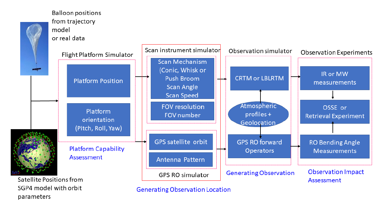
Figure: Flowchart of the satellite and near space platform simulator.

Orbit Simulator for Satellite and Near Space Platforms

ESSIC/CISESS Scientists Likun Wang, Ross Hoffman and Kayo Ide have a new manuscript accepted for publication at the Journal of Atmospheric and Oceanic Technology titled “Orbit Simulator for Satellite and Near Space Platforms Supporting Observing System Simulation Experiments”.

Read More »
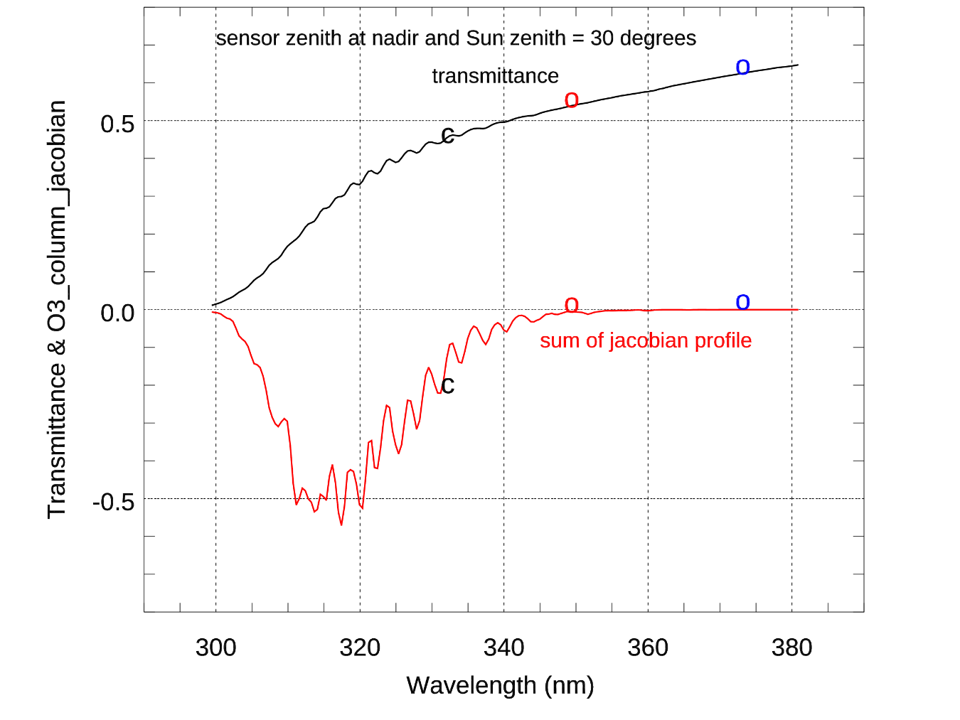
Figure: Total transmittance from surface to satellite (black line). The red line is the accumulated CRTM radiance Jacobian to ozone profile. Symbol “c” is the position at 331 nm used to estimate surface reflectance. The symbol “o” are the two channels, that we propose, to estimate the surface reflectance. The surface reflectance for other channels is either interpolated or extrapolated from the two reflectance at 347.6 nm and 371.8 nm.

UV Surface Reflectance from OMPS Nadir Mapper (NM) Radiance—Simulation and Assimilation

ESSIC/CISESS scientists Christopher Grassotti and Xingming Liang are co-authors in a recently published study that documents the first ultraviolet radiance assimilation for atmospheric ozone in the troposphere and stratosphere. The paper, titled “Experimental OMPS Radiance Assimilation through One-Dimensional Variational Analysis for Total Column Ozone in the Atmosphere”, was published in Remote Sensing and includes co-authors from the NOAA/NESDIS Center for Satellite Applications and Research.

Read More »
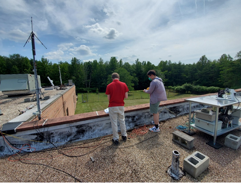
Figure: Photo of Terrence (left) and Guangyang (right) working on the GPS cable. The lightning detector is on the left-hand side of the picture. The triangle-shaped antenna detects the VHF radiation produced by lightning strikes.

DCLMA Lightning Detection Antenna Repairs

This week, ESSIC/CISESS Scientists Joseph Patton and Guangyang Fang and Summer Intern Terrence Pierce visited one of our lightning detection stations on the campus of Howard University-Beltsville. The GPS antenna for the station had been giving them trouble, so they installed new connectors for the cable that connects the GPS antenna to the lightning detection computer, and that seems to have resolved the problem.

Read More »
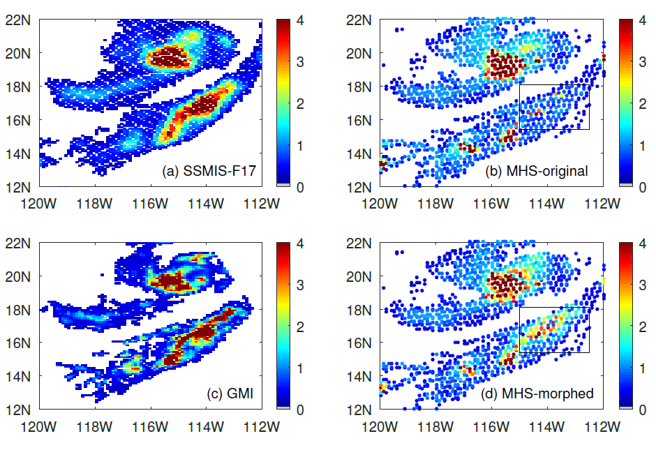
Figure: This is a precipitation event on 29 August 2020 over the Pacific Ocean near the lower California peninsula. (a) the cross-track radiometer precipitation data, (b) the conical scanning radiometer precipitation data, (c) the reference data for the event, and (d) the “morphed” radiometer precipitation data. The box shows the area of improvement due to morphing.

Improving Satellite Precipitation Retrieval

ESSIC/CISESS Scientists Yalei You, John Xun Yang, and Jun Dong have a new article on using “morphing” to improve rain data from cross-track scanning radiometers. The paper, titled “Improving Cross-track Scanning Radiometers’ Precipitation Retrieval over Ocean by Morphing”, is in press at the Journal of Hydrometeorology.

Read More »