The Chesapeake Bay is the nation’s largest estuary and ranks among the most biologically productive waterways in the world. Yet maintaining that productivity, while also managing the conflicting needs of Maryland’s economy, presents challenges for decision-makers.
ESSIC scientist Ron Vogel is working to leverage satellite data to inform and support decision-makers. In cooperation with NOAA CoastWatch, he has developed a water temperature change indicator for estuaries across the United States. The tool displays temperature changes over months or years, which can help the managers understand the impacts of high or low temperatures that may impact the estuary’s ecology.
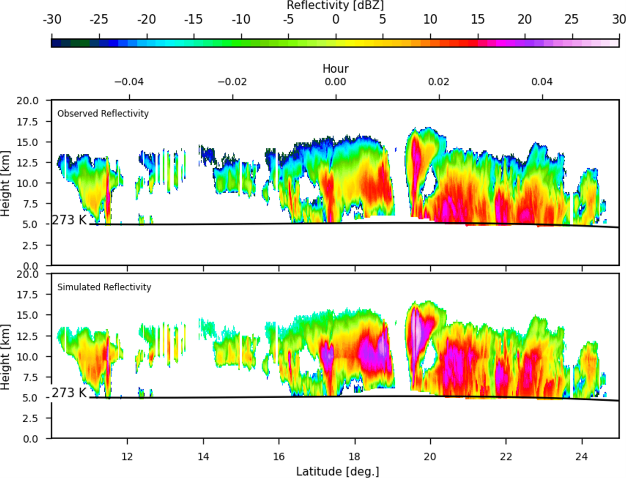
NOAA CoastWatch Data Portal estuary graphing tool for July temperatures over years since 2007 for lower Chesapeake Bay. Vogel contributes the monthly and annual average satellite temperature to NOAA for 84 estuaries across the United States.]
High temperatures in summer may limit the growth of submerged aquatic vegetation, an important fish habitat. Low temperatures in winter may cause large fish kills if the temperature falls below the tolerable range for a certain fish species such as the striped bass, an iconic Chesapeake species. High temperatures in both the winter and summer negatively impact striped bass at their larval and adult stages, respectively. Because the Chesapeake Bay is a crucial spawning and nursery ground for striped bass, negative impacts in the Bay can affect the entire population in the North Atlantic.
“Although numerous organizations collect data about Chesapeake Bay, many other estuaries nationwide do not have ship or buoy data collection programs, so the data from satellites is crucial for monitoring and understanding the impacts of these changes,” says Vogel.
Vogel is also investigating whether year-to-year and season-to-season variations in phytoplankton, the base of the food chain, can be used as an indicator of fish stock productivity. When algae or phytoplankton rapidly increases in bodies of water, the water becomes more green to reflect the presence of chlorophyll. Satellites observe the discoloration which Vogel uses to quantify the strength of phytoplankton blooms in different seasons. Strong or weak blooms in winter or spring may indicate how further links in the food chain, such as zooplankton or fish larvae, will fare in a particular year. The information may inform fishery managers if economically important species like striped bass will have a successful year-class and increase in numbers. Satellite data like this is crucial for improving the decisions affecting fisheries, which are vital to coastal economies.
Satellite seasonal temperature difference maps indicate how the Chesapeake Bay ecosystem and its organisms may respond to the temperature changes. Here, the maps show warmer than average water temperatures from January through March 2020, cooler than average from April through June, near average July through September, and slightly warmer than average October through December. The long-term baseline is from the years 2008-2019.]
By engaging directly with the decision-making community, Vogel helps to determine their needs for information, understand the specific decisions they face, and build applications that convert satellite data to actionable knowledge for improving sustainable fishery and other environmental outcomes.
“Healthy coastal ecosystems continue to provide economic benefit to local and regional communities,” said Vogel.
![NOAA CoastWatch Data Portal estuary graphing tool for July temperatures over years since 2007 for lower Chesapeake Bay. Vogel contributes the monthly and annual average satellite temperature to NOAA for 84 estuaries across the United States.]](https://essic.umd.edu/wp-content/uploads/2025/09/rv-chesapeake1-.png)

")