Low Earth Orbit Satellite Observations: A Key to Improving Tropical Cyclone Track Forecasts
Highlights
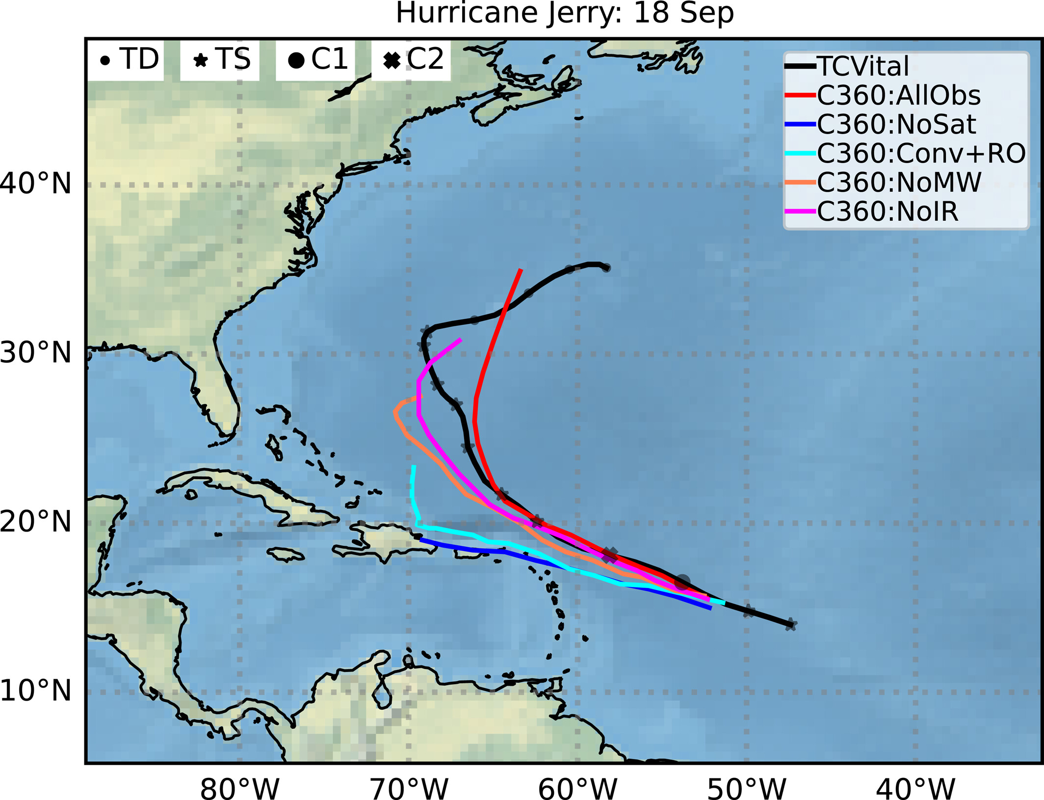
Impact of withholding different observations from the assimilation process on Hurricane Jerry's track. Forecasts were initialized on 18 September 2019, and extend up to 5 days. The markers show tropical depression (TD), tropical storm (TS), tropical cyclone category 1 (C1) and category 2 (C2).
A new study by Isaac Moradi (UMD/NASA), Satya Kalluri (NOAA), Vijay Tallapragada (NOAA), and Yanqiu Zhu (NASA) highlights the essential role of Low Earth Orbit (LEO) satellite observations in tropical cyclone prediction, particularly for forecasting storm tracks—the most critical element of tropical cyclone (TC) forecasts.
Published on May 9, 2026 in the Journal of Geophysical Research (https://doi.org/10.1029/2026JD046562), the study investigates how microwave (MW) and infrared (IR) observations from LEO satellites influence forecast accuracy within NASA’s Goddard Earth Observing System (GEOS) data assimilation framework.
Results from experiments involving multiple historical tropical cyclones show that removing LEO satellite MW and IR observations leads to a substantial degradation in track forecasts. Because track prediction determines where and when a cyclone will make landfall, it is widely considered the most important component of tropical cyclone forecasting for public safety and emergency preparedness. The study demonstrates that without these LEO-based observations, forecast confidence in cyclone paths decreases significantly, reducing the effectiveness of warnings and risk mitigation efforts.
In contrast, intensity-related forecasts—such as maximum wind speed and minimum sea level pressure—are less sensitive to the loss of LEO observations and show diminishing impacts at longer forecast lead times. The study also finds that increasing model horizontal resolution from ~25 km to ~12 km improves intensity forecasts, but provides only modest improvements in track prediction compared to the impact of observational data.
Overall, the findings underscore that LEO satellite observations play a dominant role in determining tropical cyclone track accuracy. The authors emphasize that maintaining and enhancing LEO MW and IR observing systems is crucial for sustaining reliable track forecasts, which remain the most important information for tropical cyclone warning and response decisions.

")