From crab boats to cargo ships to the bustle of Ocean City’s boardwalk, Maryland’s economic prosperity is closely tied to its coast. However, managing this vital resource isn’t simple. Competing interests between industry, tourism, conservation, and community needs creates tough choices for those tasked with protecting coastal ecosystems. Environmental managers strive to balance regional economic interests, sustainability of resources, and human and ecosystem health. This balance is increasingly hard to maintain when faced with environmental variability.
ESSIC Scientist Ron Vogel develops geospatial products and applications that allow decision-makers to understand current and past environmental conditions for making informed choices for the future. One of his most important products are satellite-based temperature maps, which depict how much hotter or colder the water is compared to a long-term average temperature. These maps help fishery managers understand how temperature may be impacting the health of fish populations.
“Seasonal departures from normal temperature can impact several species of Chesapeake Bay important to Maryland fishermen and Maryland’s economy, including blue crabs, oysters, striped bass, and summer flounder,” said Vogel, “A large percentage of the North Atlantic striped bass population uses the Chesapeake Bay as a spawning and nursery ground, so unfavorable environmental variations in Chesapeake Bay can impact the entire striped bass population for the North Atlantic.”
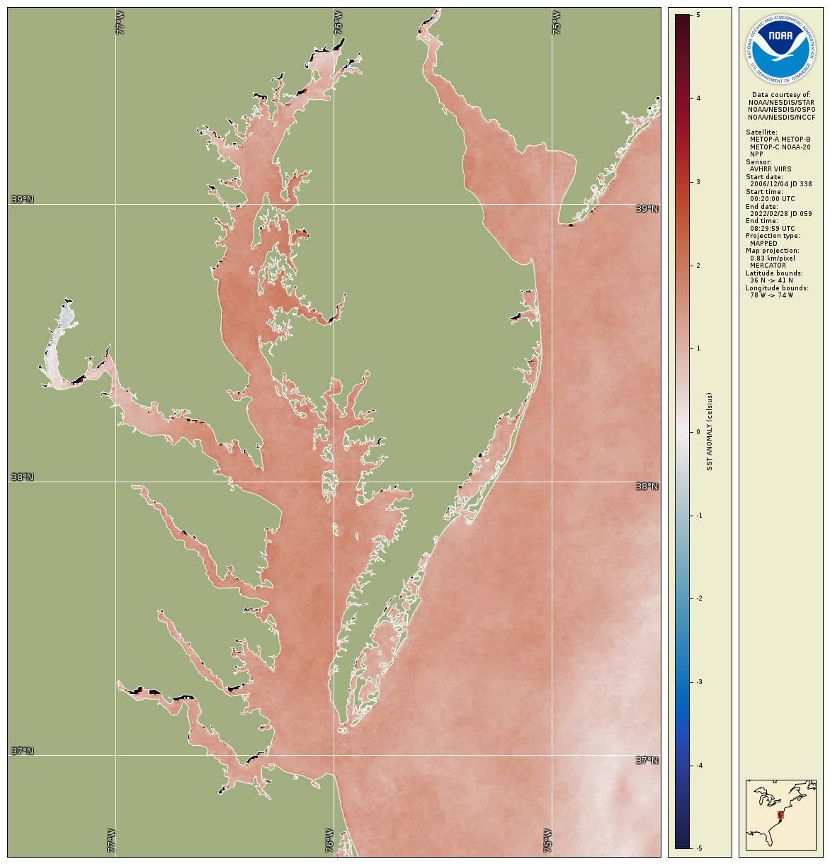
Winter 2023-2024 water temperature difference map for Chesapeake Bay from satellite data shows warmer water (red color) compared to a 2007-2022 baseline, indicating unfavorable conditions for economically key fish species in Maryland and the Mid-Atlantic region such as striped bass and bay anchovy, but favorable conditions for species such as blue crabs. Science-based information from satellites helps fishery managers in Maryland and the Mid-Atlantic plan for potential management actions to ensure fish stocks remain stable.
Vogel’s temperature maps help fishery management bodies like the Atlantic States Marine Fisheries Commission anticipate changes in the sizes of commercially important fish stocks. If stocks may potentially decline based on recent stock data and changes in environmental conditions, then fishery managers may take steps to ensure the sustainability of the fishery resource. Examples of these steps include altering the time frame when fishing is allowed, limiting the number of fishing permits issued, protecting fish spawning or nursery grounds, or in the case of aquaculture farms, siting new farms in regions with more favorable conditions.
“Without this information, fishery managers have less scientific information for deciding how and when to sustainably manage fish resources,” said Vogel, “Unsustainable management leads to crashes or large swings in fish stocks, causing Maryland fishermen to lose jobs and disrupting the economic viability of Maryland’s and the Mid-Atlantic fishing industry.”
Vogel creates products and applications like maps by working directly with the economic and environmental stakeholders to understand their decision-making needs. He also teaches satellite data analysis to expand the use of these data and ensure a technically capable workforce. He has been a subject matter expert for regional advisory councils, providing guidance on the use of satellite data to understand water turbidity fluctuations, variability in the blue crab fishery, and the impact of temperature on marine resources. He has spent over 15 years conducting scientific and applied research using satellite data for fisheries productivity, monitoring water quality and algal blooms, and the impact of satellite data products in weather forecasting models.
Environmental satellites and data products like Vogel’s are crucial for environmental managers, especially when ship or buoy measurements are lacking. Satellite measurements offer oceanographic data over broad regions on a continuous basis and over long time periods, key to understanding changes to the ecology and for coastal decision-making.
NOAA publishes ESSIC’s temperature maps for Chesapeake Bay in its reports, Synthesis of Environmental Impacts on Key Fishery Resources in the Chesapeake Bay, and State of the Ecosystem Report – Mid-Atlantic.

")