An unusual heat wave struck Alaska this past June (2013), with temperatures reaching well into the 80’s and 90’s throughout the state. Instead of temperatures in the mid-60s, the average in places near Anchorage, people were basking in the sun and visiting local beaches in response to the unusually high temperatures.
Unofficial readings of 98°F were recorded in northern parts of Alaska near Talkeetna, which would tie the highest recorded temperature in the area. Anchorage felt the heat as temperatures reached 81°F, breaking its previous record of 80°F, set in June of 1926.
Oddly, the heat wave follows a severe winter in Alaska that lasted until the end of May, coupled with below average temperatures this past spring.
ESSIC Research Associate, Dr. Michael Folmer, who was attending a meeting in the Anchorage and Fairbanks regions during the height of the extreme event, discussed the phenomena in a recent interview
According to Folmer, the term “heat wave” represents a period of uncharacteristically above normal temperatures. Since most regions of Alaska seldom experience readings above 85° Fahrenheit, the designation of the term “heat wave” in this instance, referred to temperatures consistently exceeding that benchmark.
Heat waves are produced from abnormally strong pressure ridges in the jet stream pattern, which results in the atmosphere getting stuck.
Folmer believes this heat wave isn’t necessarily indicative of any future weather patterns in Alaska. “It’s really tough to gauge long-term, because Alaska is no stranger to heat; some of the record high temperatures in Alaska weren’t even met during this heat wave,” Folmer said.
Folmer surmised that what makes this particular situation unusual is not necessarily the heat wave itself, but the interplay of extreme weather. Although Alaska tends to experience at least one heat wave per summer – typically in late June to July – it already had experienced a much cooler spring and longer winter this year, as compared to past seasonal averages.
Unusual weather patterns alone aren’t necessarily representative of a changing climate however; Folmer noted that the extremes of the past year can only be viewed as anomalies at this time. A longer duration of extreme events or deviations would be required in order to suggest a climate change correlation.
However, the heat wave did result in several identifiable near-term implications for the region. Folmer stated that wildlife, (except for mosquitoes which were thriving), was relatively absent from areas generally known to support fairly high animal activity. (According to Yahoo! News, the mosquitos Folmer is likely referring to are Asian Tiger mosquitoes, a breed of fast-flying, day biting insects that only emerge in warmer weather.)
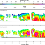
Additionally, the risk of wildfires can also greatly increase when the air heats up, especially during the summer months when campers – some with little experience- flock to the region. Folmer noted experiencing a rare regional thunderstorm (see included image at top of page), which could also pose wildfire risk from lightning.
Folmer mentioned that although he wasn’t in an area known for glaciers, there was no noticeable effect on ice or snow packs. In fact, last year at this time, the ice sheets covering northern Alaska were already retreating from the coastlines. This year, ice sheets have remained against the coastline – the heat wave notwithstanding – due to the unusually long winter-cold spring.
Folmer, a satellite liaison for various NOAA weather centers, has expertise in tropical meteorology and satellite meteorology. He holds a bachelors of science in Meteorology from the University of Miami, and a masters/doctorate of philosophy from Saint Louis University.


