Home » Cryosphere » Page 3

Tag: Cryosphere

Figure. Snowfall products and report for the snowstorm on March 15, 2021 around 4:30 UTC, (a) satellite-radar merged snowfall rate (mSFR); (b) MRMS radar instantaneous snowfall rate; (c) SNODAS hourly snowfall analysis; (d) mPING crowdsourcing weather report.

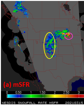
Satellites Fill in Radar Gaps in Snowstorm

Some western and central states experienced a strong winter storm on March 13-15. The experimental satellite-radar merged snowfall rate product (mSFR) previously covered in ESSIC News demonstrated how satellites could fill in radar gaps in regions with limited or no radar coverage.

Read More »
A scenic view of the ocean and the beach

Farrell and Thomas Discuss the Hidden Talents of ICESat-2

A new NASA Goddard feature highlights how the Ice, Cloud, and Land Elevation Satellite 2 (ICESat-2), originally intended to precisely measure the height of the ice sheets at Earth’s poles, of sea ice floes above the ocean waters, and of forest canopies, has gone beyond its original purposes to map the Earth’s surface. In the article, ESSIC/CISESS scientists Sinéad Farrell and Nathan Thomas are quoted discussing these unintended benefits.

Read More »
Snowy dunes of the Larsen C

Operation IceBridge Awarded Robert H. Goddard Award

Last June, NASA’s Operation IceBridge mission, an ongoing effort to monitor changes in polar ice, was awarded a Robert H. Goddard award for Science Teams. On this team is Alek Petty, ESSIC Associate Research Scientist, who has made substantial contributions as a member of the missision’s Project Science Office.

Read More »