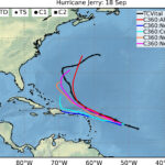
Skip to content
ESSIC-CMYK-left (15)
  • About 
    • Leadership
    • History 
      • History of ESSIC
      • Past Leadership
      • Land Acknowledgment Statement
    • Administrative and Technical Contacts
    • Employment
    • Gift Fund
    • Location & Directions
  • People
  • Research 
    • Research Themes 
      • Atmospheric Composition and Processes
      • The Global Carbon Cycle
      • Climate Variability and Change
      • The Global Water Cycle
    • Projects 
      • Global Precipitation
      • Satellite Observations
    • CISESS
    • Climate Resilience Network
  • Education
  • News 
    • Highlights
    • Features and Press Releases
    • Outreach
  • Seminars 
    • About Seminars
    • Upcoming Seminars
    • Past Seminars
    • Seminar Recordings

Zeng interviewed by PBS Newshour

  • December 1, 2009
  • Archive

Ning Zeng was interviewed by PBS Newshour/TheNews for an educational program on climate impacts of El Nino: http://www.pbs.org/newshour/thenews/.

PrevPreviousFarquhar quoted in ScienceNews
NextZhang and Dickerson publish article in Geophysical Research LettersNext

Latest News

Figure 1. Damian Figueroa, Guangyang Fang, and Samuel Wiggins (From left to right) at the AWE USA Conference in Long Beach, CA.

CISESS Goes to Augmented World Expo

August 1, 2025
Figure. Seasonal climatologies (1987–2022) for wind profiles extrapolated from NOAAOffshoreWindProfiles-USA (unit: m s-1) at (a-d) 20, (e-h) 100, and (i-l) 200 m. DJF: December, January, February; MAM: March, April, May; JJA: June, July, August; SON: September, October, November.

Introducing a High Resolution Atlas of U.S. Offshore Wind Profiles

August 1, 2025
Winter 2023-2024 water temperature difference map for Chesapeake Bay from satellite data shows warmer water (red color) compared to a 2007-2022 baseline, indicating unfavorable conditions for economically key fish species in Maryland and the Mid-Atlantic region such as striped bass and bay anchovy, but favorable conditions for species such as blue crabs. Science-based information from satellites helps fishery managers in Maryland and the Mid-Atlantic plan for potential management actions to ensure fish stocks remain stable.

How Satellites Help Maryland’s Coastal Economy

July 21, 2025
Figure. Two images showing the same geographical area. (Left) VIIRS 375-m daily floodwater extent product on 4 July 2025, with the locations of the Guadalupe River and the towns of Ingram and Kerrville superimposed. Cloudy conditions were in place so no flood inundation information was available, hence the gray background. (Right) The SAR flood inundation map on 4 July 2025, showing some flooded areas (in red).

Mapping the Extent of the Devastating July 4 Texas Flash Flood Event

July 14, 2025
Permafrost thaw bogs in the Northwest Territories, Canada. A nearby fire caused haze in the scene. Photos were taken from a helicopter.

What Can Wetlands Tell Us About Methane Emissions?

July 8, 2025

Connect with ESSIC

Facebook Icon-twitter-x Youtube Linkedin

Links

About Us

UMD Home

ESSIC Business Office

ESSIC IT Helpdesk

Privacy Notice

Web Accessibility

Contact Us

  • 5825 University Research Ct., Ste. 4001, College Park, MD 20740-3823
  • Phone: (301) 405-0050
  • Contacts
  • Directions to ESSIC
Last Updated: 6 August 2025