")
The American Meteorological Society Annual Meeting was held last week, January 12 to 16, in Boston. There were significant contributions by ESSIC/CISESS scientists, documented here.
Ralph Ferraro was the lead author on an invited presentation about the “Use of Satellite Precipitation Products to Improve Hydrologic Prediction and Modeling” which was presented by Nai-Yu Wang of ESSIC/CISESS. He also co-authored a talk on hydrological climate data records (presented by J. Beauchamp, CISESS) and another on the use CYNGNSS data for hydrological prediction (presented by N-Y. Wang, CISESS).
Both Ferraro and H. Meng coauthored a poster on the NOAA/NESDIS Satellite Snowfall Rate Product. Meng and S. Rudlosky coauthored a talk on the time lag between satellite measurements and surface precipitation that was presented by Yalei You (CISESS). Rudlosky also worked on the two talks on satellite data in virtual reality.
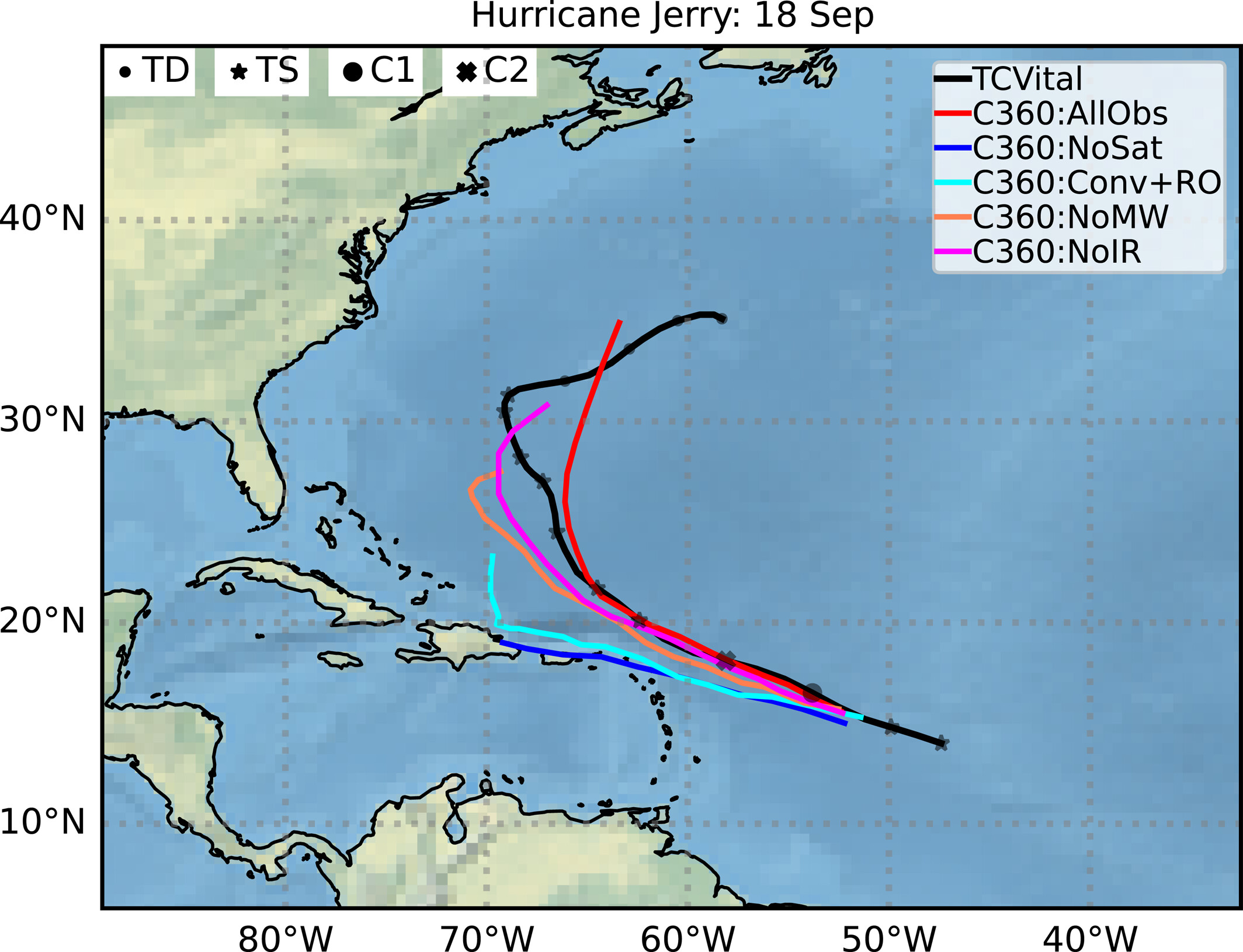
T. Smith co-authored a poster with his CREST PhD Student Equisha Glenn on The Role of Convection on the Decreasing Caribbean Precipitation during a Regional, Warming Sea Surface Temperature Period: 1982–2017.
ESSIC/CISESS Scientist Jonathan Wynn Smith and Consortium Scientist Steve Goodman presented a day-long AMS Short Course called “From GOES-R and JPSS Satellites to Disaster Response: Every Decision Counts.” Both S. Rudlosky and H. Meng made significant contributions to developing the case studies used at the training. Graduate student Eli Dennis (advisor: Hugo Berbery) chaired the Python Workshop.
Hydrological satellite products were the focus of several ESSIC/CISESS presenters:
-
- Nai-Yu Wang (and Christopher Grassotti) on the Use of Satellite Precipitation Products to Improve Hydrologic Prediction and Modeling (Invited Presentation);
- Nai-Yu Wang on the Potential GNSS-R CYGNSS Land Applications for NOAA’s Hydrological Predictions;
- Yalei You (and Jun Dong) on Time‐Lag Correlation between Passive Microwave Measurements and Surface Precipitation and Its Impact on Precipitation Retrieval Evaluation;
- James Beauchamp on AMSU Climate Data Records and Their Use in Hydrological Climate Studies
Jun Dong and Cezar Kongoli also had a poster on Recent Development in NOAA/NESDIS Satellite Snowfall Rate Product and Its Applications. Robert Adler, who worked with NOAA on the GPCP precipitation product, gave three talks on:
-
- The Global Precipitation Climatology Project (GPCP)—Means, Variations, and Trends over the Satellite Era
- Real-Time Analysis of the 2019 Mozambique Flood Using Satellite Rainfall and the Global Flood Monitoring System (GFMS)
- Validating CMIP/AMIP Calculations with Global Precipitation Observations during the Satellite Era: Means, Trends, and Intensity Changes.
Michael Gerst, Mike Maddox, and Melissa Kenney presented a paper alongside co-authors L. Guntuka, S. Boyson: Developing an Index for Measuring Supply Chain Vulnerability to Climate Change.
Jifu Yin and Mitch Schull gave a talk on droughts: Objective Integration Soil Moisture Satellite Observations and Model Simulations toward a Blended Drought Index.
Patrick Meyers gave two talks on the CISESS Virtual Reality Project. Mason Quick and Katherine Lukens were coauthors on these talks as well:
-
- Exploring Satellite Observations in Virtual Reality
- Examining an Atmospheric River in Virtual Reality
Kayo Ide’s Data Assimilation group gave four talks:
-
- Erin Jones (Yingtao Ma and Kayo Ide) on Efforts to Evaluate Shortwave Observations from the CrIS Hyperspectral Infrared Instrument in the NOAA Global Data Assimilation System
- Hui Liu (and Kayo Ide) on Initial Impact Assessment of ADM-Aeolus Wind Observations on NCEP Global Analysis and Forecast
- Katherine Lukens (Kayo Ide, Hui Liu and Ross Hoffman) on Error Characterization of Atmospheric Motion Vectors through Intercomparison with ADM-Aeolus, NWP, and In Situ Observations
- Yingtao Ma (Kayo Ide, Erin Jones and Katherine Lukens) CRTM Improvement toward the Assimilation of SW IR Radiances
In addition, Ross Hoffman chaired the session on Observing System Simulation Experiments (OSSEs) at the 24th Conference on Integrated Observing and Simulation Systems for the Atmosphere, Ocean and Land Surface (OAS-AOLS).
Xi Shao’s group, with NOAA Lead Changyong Cao, gave two talks:
-
- Sirish Uprety (Bin Zhang and Xi Shao) on Establishing Operational Earth Observation Data Continuity Using VIIRS and METimage; and
- Bin Zhang (and Xi Shao) on Error Assessments in the GNSS Radio Occultation Excess Phase/Bending Angle Calculation.
They also presented a poster:
-
- Xi Shao, Xin Jing, Bin Zhang and A.S. Sharma on SNO-Based Radiometric Bias Evaluation for Emulated Small Satellite Microwave Sensors.
AMS participant also heard about CISESS calibration and validation projects:
-
- Hyelim Yoo (and Fangfang Yu) on GEO-GEO Intercomparison as a Tool for Instrument Characterization
- Yong-Keun Lee (Christopher Grassotti and Yan Zhou) on The Microwave Integrated Retrieval System (MiRS): Validation Activities for NOAA-20/ATMS Products and New Science Developments
- Yan Zhou (Christopher Grassotti and Yong-Keun Lee) on Development of a Machine Learning–Based Radiometric Bias Correction for NOAA’s Microwave Integrated Retrieval System (MiRS)
Jeannette Wilde also presented a poster on Validation of SAGE III-ISS Ozone with NOAA OMPS and Ground-Based Instruments.
Hugo Berbery’s graduate student Eli Dennis presented his poster in the new format designed to make browsing posters easier by putting the main message as the focal point.