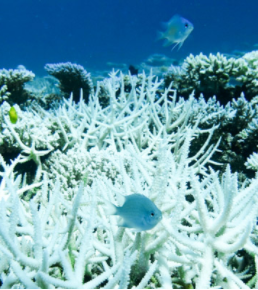
Home » Cazzy Medley » Page 27

Author: Cazzy Medley

Figure: Case study of August 11, 2018. Convective/stratiform split of the raining system observed by GPM-core satellite (orbit: 025293). From left to right: (a) PMW-retrieved (GPROF) – a current operational benchmark; (b) Dual-frequency Precipitation Radar-derived product – the truth; (c) Bayesian model prediction ResNetV2; (d) Entropy for the Bayesian model prediction – uncertainty map.

Using Bayesian Deep Learning to Improve Precipitation Retrievals

ESSIC/CISESS Scientist Veljko Petković co-authored a study on the application of new and emerging field of BDL concepts to mitigate problems associated with the accuracy of precipitation retrievals from satellite-borne passive microwave (PMW) radiometers, which was published in IEEE Geoscience and Remote Sensing Letters.

Read More »
Figure: A rosette of Niskin (seawater sampling) bottles used to collect discrete water samples at specific, predetermined depths. Instruments for measuring depth, temperature, and conductivity (which helps determine salinity) are inside of the ring near the bottom (not visible). (Photo provided to Jiang et al. by Sabine Mecking of the University of Washington for the publication).

Jiang Leads International Effort to Create New Data Standard for Oceanographic Research

ESSIC/CISESS Scientist Li-Qing Jiang, who works on the Ocean Carbon Acidification Data System (OCADS) project at the National Center for Environmental Information (NCEI), coordinated a massive effort by the international community to develop a best practice data standard for discrete bottle-based chemical oceanographic data. The study, co-authored by ESSIC/CISESS Scientist Alex Kozyr and esteemed scientists at over 30 institutions in 10 countries, was published on January 21st in Frontiers in Marine Science.

Read More »
The title slide of the AMS short course

CISESS Presents Two AMS Short Courses

Scott Rudlosky and Joseph Patton led an AMS short course titled “Accessing and Applying Geostationary Lightning Mapper Observations” on January 5 and 6. This two-part course introduced the GLM observations and imagery using GLM flash skeletons and gridded products used by the National Weather Service. Participants were shown how to access archived and real-time imagery before conducting a hands-on exercise illustrating their new-found skills. Additional information can be found at this link: Accessing and Applying Geostationary Lightning Mapper Observations.

Read More »
Figure 1 | Flooding in July 2021 caused mass evacuation in Weihui, Henan province, in China.

Extreme Rainfall Slows the Global Economy

Xin-Zhong Liang was recently published in Nature’s “News and Views” section giving his insight on new research that reported a comprehensive assessment of changes in gross regional product (GRP) relating to excessive precipitation. The study concluded that increases in the numbers of wet days and in extreme daily rainfall dramatically reduces worldwide macroeconomic growth rates.

Read More »
Snow falling around some pine trees

Snowfall Rate Product Captures First Nor’easter in 2022

The first nor’easter of 2022 swept through the Mid-Atlantic and the Northeast on January 2-4, 2022, resulting in a heavy snow accumulation of up to 14 inches in Virginia and southern Maryland and stranding hundreds of drivers on Interstate 95 in Virginia. The NOAA NESDIS Snowfall Rate (SFR) product captured the evolution of the snowstorm with retrievals from the Advanced Technology Microwave Sounder (ATMS) sensor aboard the S-NPP and NOAA-20 satellite missions, and the AMSU-A/MHS sensors aboard NOAA-19, Metop-B, and Metop-C.

Read More »