University of Maryland

Quick-Hitting Atlantic Gale

UMD/ESSIC/CISESS GOES-R Satellite Liaison for NWS WPC

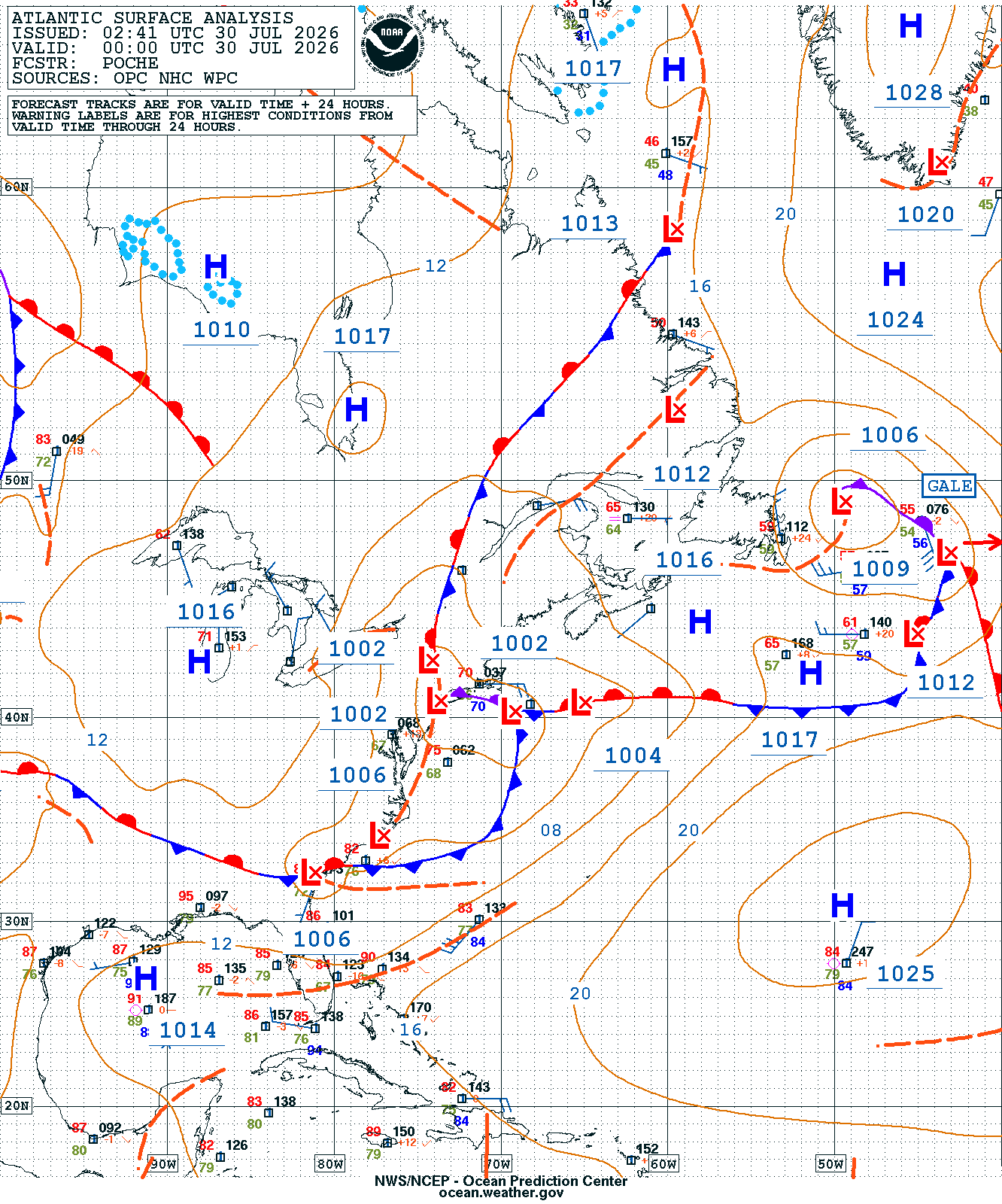
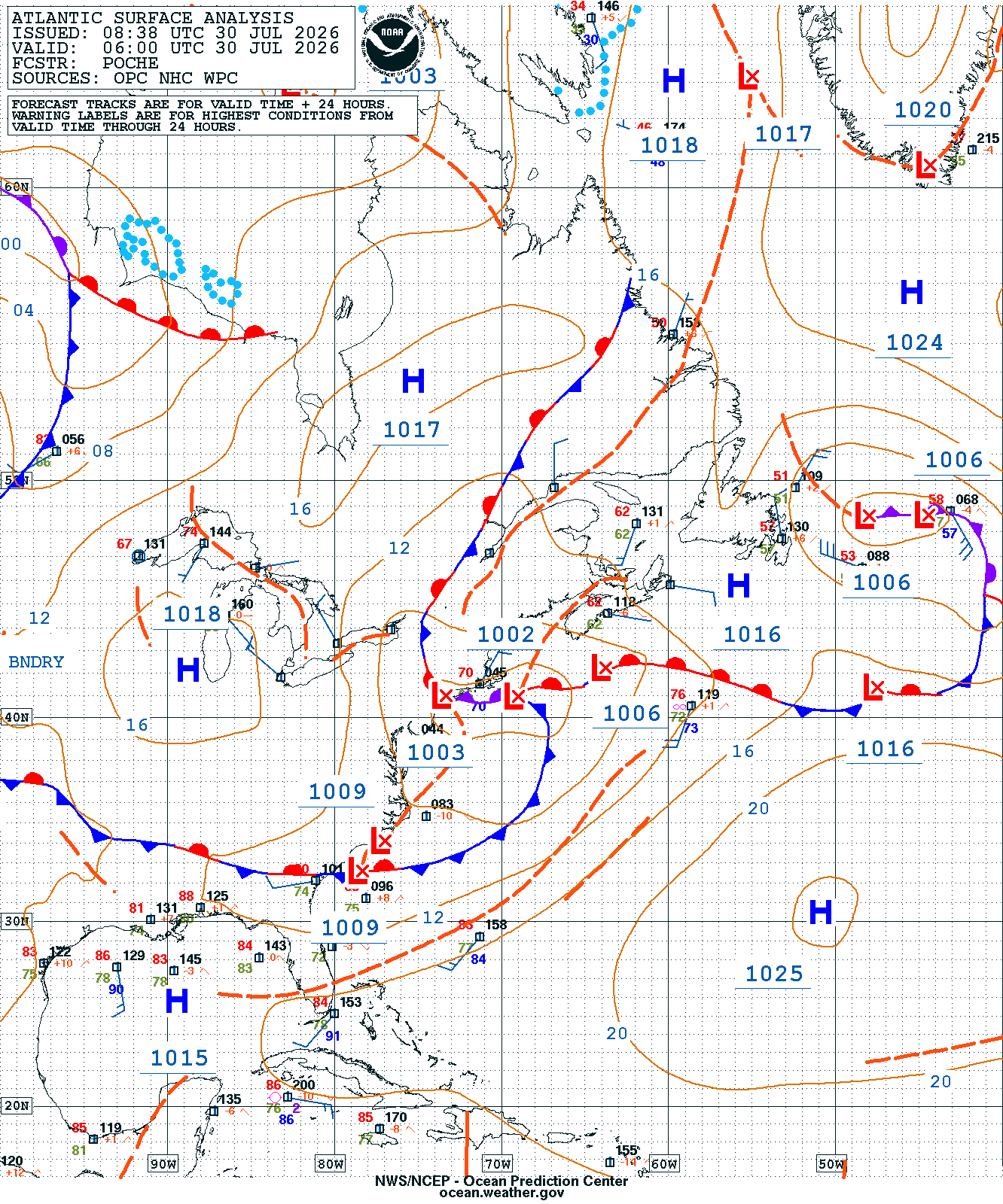
The NWS Ocean Tsunami Center (OTC) analyzed a quick-hitting Atlantic gale-force low last week, likely fueled by anomalously warm sea surface temperatures (SSTs) at higher latitudes that enhanced instability and atmospheric mixing to transport stronger winds down to the surface. The gale-force low was analyzed east of Newfoundland at 0000 UTC 30 July 2026, only to have its strength drop below gale-force six hours later.

Surface Analysis
NWS Surface Analysis

Figure 1: NWS OTC Surface Analysis at 0000 UTC (left) and 0600 UTC (right) 30 July 2026.

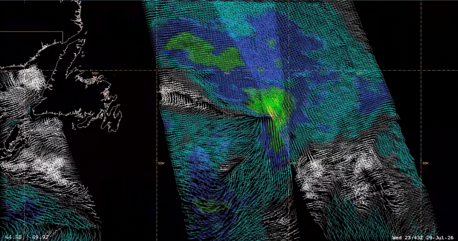
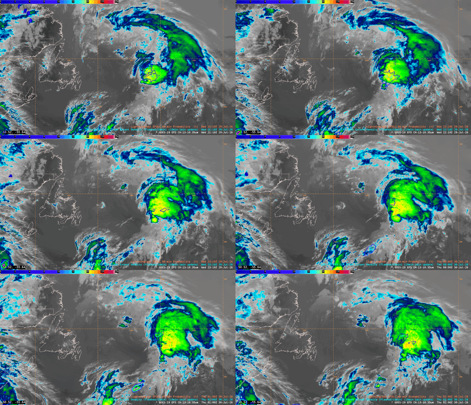
When designating this gale, an OTC forecaster acknowledged that the Metop-ASCAT showed gale-force winds northeast of ‘the triple point of low east of Newfoundland’. Another forecaster also noted elevated LightningCast probabilities ‘in that area with the higher clouds. It seems to be related, so perhaps some higher winds are mixing down…The models don’t show much more than 25 kt’. While lightning wasn’t observed directly where LightningCast had higher probabilities, the GLM FED did indicate lightning in the system’s northwest quadrant. LightningCast is more accurate during the day, according to the Quick Guide.

Metop-B ASCAT
Figure 2: Metop-B ASCAT passes showing an area of gale-force winds (yellow) from ~2215 UTC 29 July to ~0000 UTC 30 July 2026. This image was exported from AWIPS, and display files can be shared upon request.
GOES-East Full Disk (FD) Band 13 Infrared imagery
Figure 3: GOES-East Full Disk (FD) Band 13 Infrared imagery, overlaid with GOES-East FD LightningCast output and GLM Flash Extent Density (FED) from ~2100 UTC 29 July to ~0200 UTC 30 July 2026. This animation was exported from AWIPS, and display files can be shared upon request.

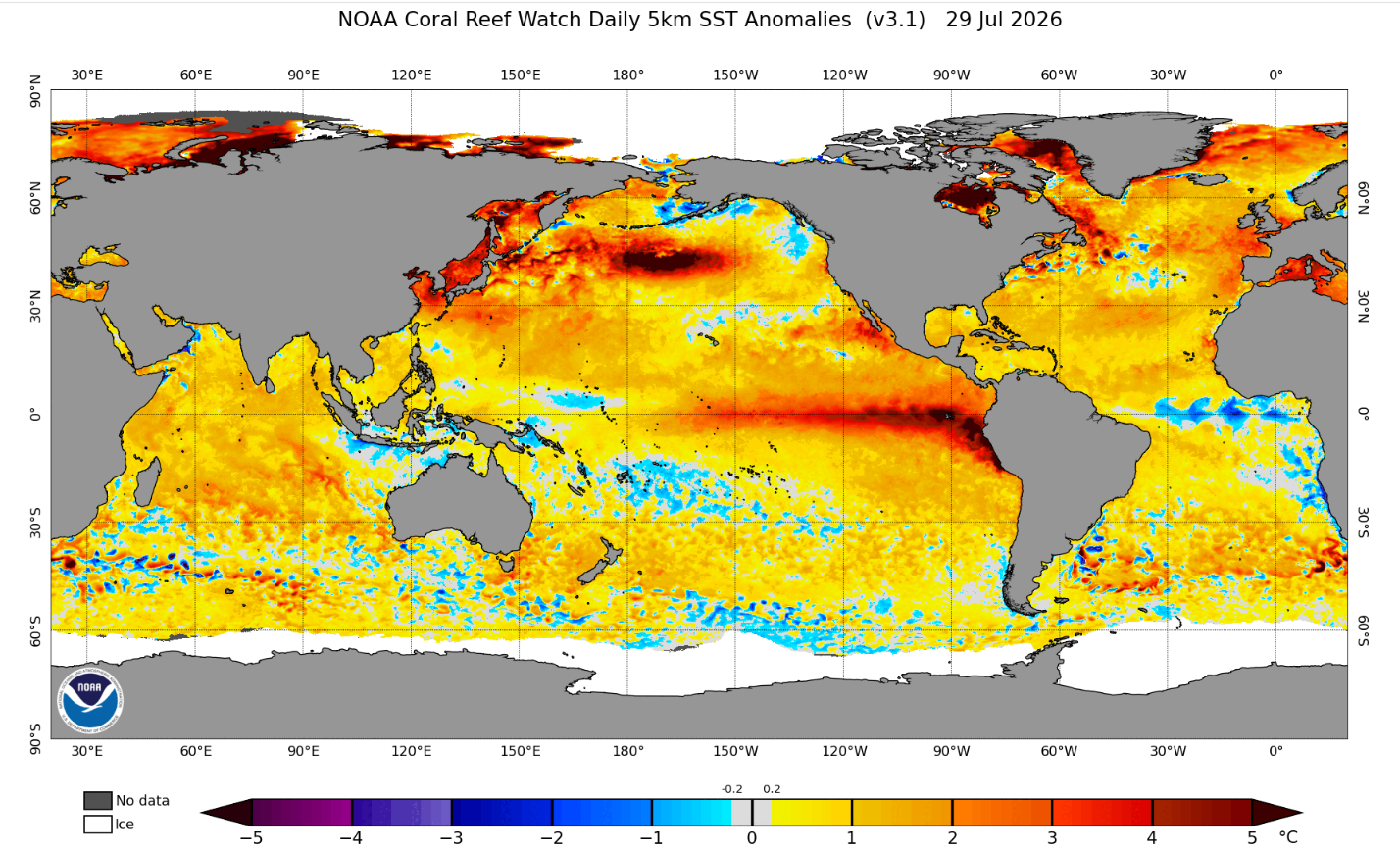
An OTC forecaster also related the enhanced mixing to ‘an area of warm SSTAs was helping to lower stability, and cause greater mixing. It looks like the SSTs cool off near 40W, and the convection seems to be dying down with the system is moving into that region of cooler SSTs’ (when the system indeed dropped below gale-force). The forecaster referenced the NOAA Coral Reef Watch Daily 5km SST Anomalies product.

NOAA Coral Reef Watch Daily 5km SST Anomalies
Figure 4: NOAA Coral Reef Watch Daily 5km SST Anomalies for 29 July 2026. Credit: NESDIS/STAR

Warm and cool SST anomalies in close proximity, and other SST gradients such as the Gulf Stream, are often sources for increased mixing and unstable air that can cause enhanced winds. The GeoXO Sounder will provide frequent temperature and moisture profiles that can diagnose changes in marine boundary-layer stability associated with warm SSTs, strong SST gradients, and instability that can enhance convection. These observations can help identify where enhanced mixing is likely, improving confidence in marine wind forecasts and potentially increasing warning lead time.

Picture of Christopher Smith

Christopher Smith

Christopher Smith joined ESSIC/CISESS, University of Maryland in 2023 and is the GOES-R Satellite Liaison for the NWS Weather and Ocean Prediction Centers. Smith works to interpret experimental satellite imagery and products, and make such products available to forecasters and the NWS for a route to operations. He trains forecasters how to use satellite imagery in weather forecasting, while also delivering forecaster feedback to satellite developers to maximize meteorological satellite capabilities. Smith is an alumni of the UMD Atmospheric & Oceanic Science (AOSC) Department, and his long-term interests include infusing AI-Satellite Products to increase lead time in decision making for forecasters.